 Tweet
Tweet
Quick Land Navigation Primer copyright 2005 Robert Henry
Grab your compass and a topographical map.
Ready? O.K. let's do a basic exercise in Map and compass.
I'll assume that you know the basic symbols and colors on a topographic map- green means vegetations (woods, pasture, etc.), brown is generally used in contour lines, blue is water or marsh, black is generally used for manmade items such as roads, houses, etc.
On the bottom of the map will be a whole lot of information that is helpful to you. Let's start by figuring out what scale the map is. This will be notated in a ratio such as 1:50,000 which means 1 inch on the map equals 50,000 feet on the ground. Common scale sizes for topographic maps also include 1:24,000 scale which I prefer. The smaller scale maps, such as the 1:24,000 scale will show you more detail than the larger scale maps. The downside is that if you have a large area of operations, you may need to carry two maps. For our purposes, I think it's important to have the higher amount of detail that's available on the 1:24,000 maps. You'll have to decide for yourself.
I highly recommend that you cover all your maps with a clear plastic covering. Office supply stores have this available fairly cheap. It helps protect the map against moisture and also gives you a surface to make temporary notations on with a dry erase marker.
It might be a good time to say that you should never make any permanent notations on the map regarding routes, caches, rally points, location of your retreat, etc. Heck, just the way you fold the map tells a lot of information.
So let's look how we would plan travel on the map.
First things first, let's get the map and compass "on the same page" sort of speak.
There are three Norths, Grid North which is North on a map, Magnetic North which is North that your compass points to, and True North which is the North pole. We will only concern ourselves with Grid North and Magnetic North. Unless you plan on buggin out to the North pole, True north shouldn't have a lot of meaning to you.
We will start by laying our map out on the ground. North on a map is generally up. The legend on the bottom of the map will show an arrow for grid North also.
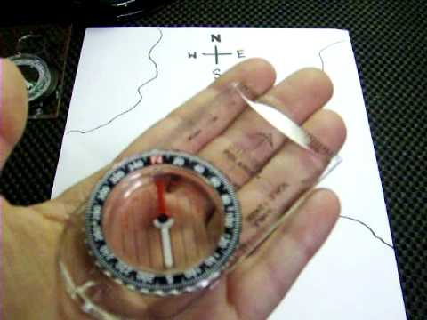
Next, take your compass out and find North on your compass (magnetic North). Rotate your map until North on the map (Grid North) is the same as North on your compass. The easiest way to show people how to do this is to lay the straightedge of the compass on one of the North-South lines on the map, then rotate until the compass reads North. Double check that the compass is still following the north-south line.
Back to the bottom of the map. We need to find the G-M angle. In some areas this won't be much of an issue, in other areas it will, it's always important to check the map though. At the bottom of the map you will see a small angle that shows Grid North and Magnetic North. This angle will have a notation such as "+1 degree" This angle refers to the difference between Grid and magnetic North (G-M angle). Often times, it is so small you do not have to worry about it. If it's more than 1/2 a degree, I usually factor it in, unless the trip is a very short one.
O.K., so the map and compass are both "on the same page" or orientated. Every time you work with a map, this ought to be the first thing you do.
Now, pick a point on the map, any point. If you got it covered in plastic, mark that point with your dry erase marker. We will call that Point A. Pick another point on the map, a distance away from Point A. Mark that, we will call that one Point B.
Using the straightedge on your compass, draw a line between Point A and Point B.
If your map is still orientated (doesn't hurt to double check), you can figure out how you would get from Point A to Point B simply by lining your compass up on the line you drew. Let's say it's 60 degrees. That's your compass bearing, or azimuth. That's the direction you would need to walk on the ground to get from Point A to Point B.
OOPS! Did we forget the G-M angle? The G-M angle told us to ADD one degree, so now our azimuth is 61 degrees.
So, if we were at Point A and wanted to walk to Point B, the compass bearing of 61 degrees would get us there.
But how far is it?
Knowing the distance is important for many factors, including what to carry, how long the trip will take, etc.
Go back to the bottom of the map and you will find a distance line. Using the straightedge of your compass again, measure the distance of the line you drew between Point A and Point B and find the distance on the distance line on the bottom of the map. That's how far you have to travel to get to Point B from Point A.
Now you have a compass bearing and a distance. Now you can travel from Point A to Point B. Simple enough?
In the future we will look at how to find our position on the map when we don't know where we are.
All for now, as always, I hope this information helped you. Till next time.
RH
Grab your compass and a topographical map.
Ready? O.K. let's do a basic exercise in Map and compass.
I'll assume that you know the basic symbols and colors on a topographic map- green means vegetations (woods, pasture, etc.), brown is generally used in contour lines, blue is water or marsh, black is generally used for manmade items such as roads, houses, etc.
On the bottom of the map will be a whole lot of information that is helpful to you. Let's start by figuring out what scale the map is. This will be notated in a ratio such as 1:50,000 which means 1 inch on the map equals 50,000 feet on the ground. Common scale sizes for topographic maps also include 1:24,000 scale which I prefer. The smaller scale maps, such as the 1:24,000 scale will show you more detail than the larger scale maps. The downside is that if you have a large area of operations, you may need to carry two maps. For our purposes, I think it's important to have the higher amount of detail that's available on the 1:24,000 maps. You'll have to decide for yourself.
I highly recommend that you cover all your maps with a clear plastic covering. Office supply stores have this available fairly cheap. It helps protect the map against moisture and also gives you a surface to make temporary notations on with a dry erase marker.
It might be a good time to say that you should never make any permanent notations on the map regarding routes, caches, rally points, location of your retreat, etc. Heck, just the way you fold the map tells a lot of information.
So let's look how we would plan travel on the map.
First things first, let's get the map and compass "on the same page" sort of speak.
There are three Norths, Grid North which is North on a map, Magnetic North which is North that your compass points to, and True North which is the North pole. We will only concern ourselves with Grid North and Magnetic North. Unless you plan on buggin out to the North pole, True north shouldn't have a lot of meaning to you.
We will start by laying our map out on the ground. North on a map is generally up. The legend on the bottom of the map will show an arrow for grid North also.
Next, take your compass out and find North on your compass (magnetic North). Rotate your map until North on the map (Grid North) is the same as North on your compass. The easiest way to show people how to do this is to lay the straightedge of the compass on one of the North-South lines on the map, then rotate until the compass reads North. Double check that the compass is still following the north-south line.
Back to the bottom of the map. We need to find the G-M angle. In some areas this won't be much of an issue, in other areas it will, it's always important to check the map though. At the bottom of the map you will see a small angle that shows Grid North and Magnetic North. This angle will have a notation such as "+1 degree" This angle refers to the difference between Grid and magnetic North (G-M angle). Often times, it is so small you do not have to worry about it. If it's more than 1/2 a degree, I usually factor it in, unless the trip is a very short one.
O.K., so the map and compass are both "on the same page" or orientated. Every time you work with a map, this ought to be the first thing you do.
Now, pick a point on the map, any point. If you got it covered in plastic, mark that point with your dry erase marker. We will call that Point A. Pick another point on the map, a distance away from Point A. Mark that, we will call that one Point B.
Using the straightedge on your compass, draw a line between Point A and Point B.
If your map is still orientated (doesn't hurt to double check), you can figure out how you would get from Point A to Point B simply by lining your compass up on the line you drew. Let's say it's 60 degrees. That's your compass bearing, or azimuth. That's the direction you would need to walk on the ground to get from Point A to Point B.
OOPS! Did we forget the G-M angle? The G-M angle told us to ADD one degree, so now our azimuth is 61 degrees.
So, if we were at Point A and wanted to walk to Point B, the compass bearing of 61 degrees would get us there.
But how far is it?
Knowing the distance is important for many factors, including what to carry, how long the trip will take, etc.
Go back to the bottom of the map and you will find a distance line. Using the straightedge of your compass again, measure the distance of the line you drew between Point A and Point B and find the distance on the distance line on the bottom of the map. That's how far you have to travel to get to Point B from Point A.
Now you have a compass bearing and a distance. Now you can travel from Point A to Point B. Simple enough?
In the future we will look at how to find our position on the map when we don't know where we are.
All for now, as always, I hope this information helped you. Till next time.
RH

Comment